1. Johnsons Hillock Locks
From the top lock pub, cross the canal bridge, take the towpath steps to head down the flight of 7 locks until you reach the junction with the old Lancaster Canal south section
This self-guided circular heritage walk covers the old southern section of the Lancaster Canal that later became the Walton Summit branch of the Leeds and Liverpool Canal, including two tunnels, an aqueduct and basin at Whittle.
The walk starts at the very picturesque flight of seven locks built in 1814/15 by the Lancaster Canal Company, which takes you down to the junction of the two canals at Johnsons Hillock bottom lock.
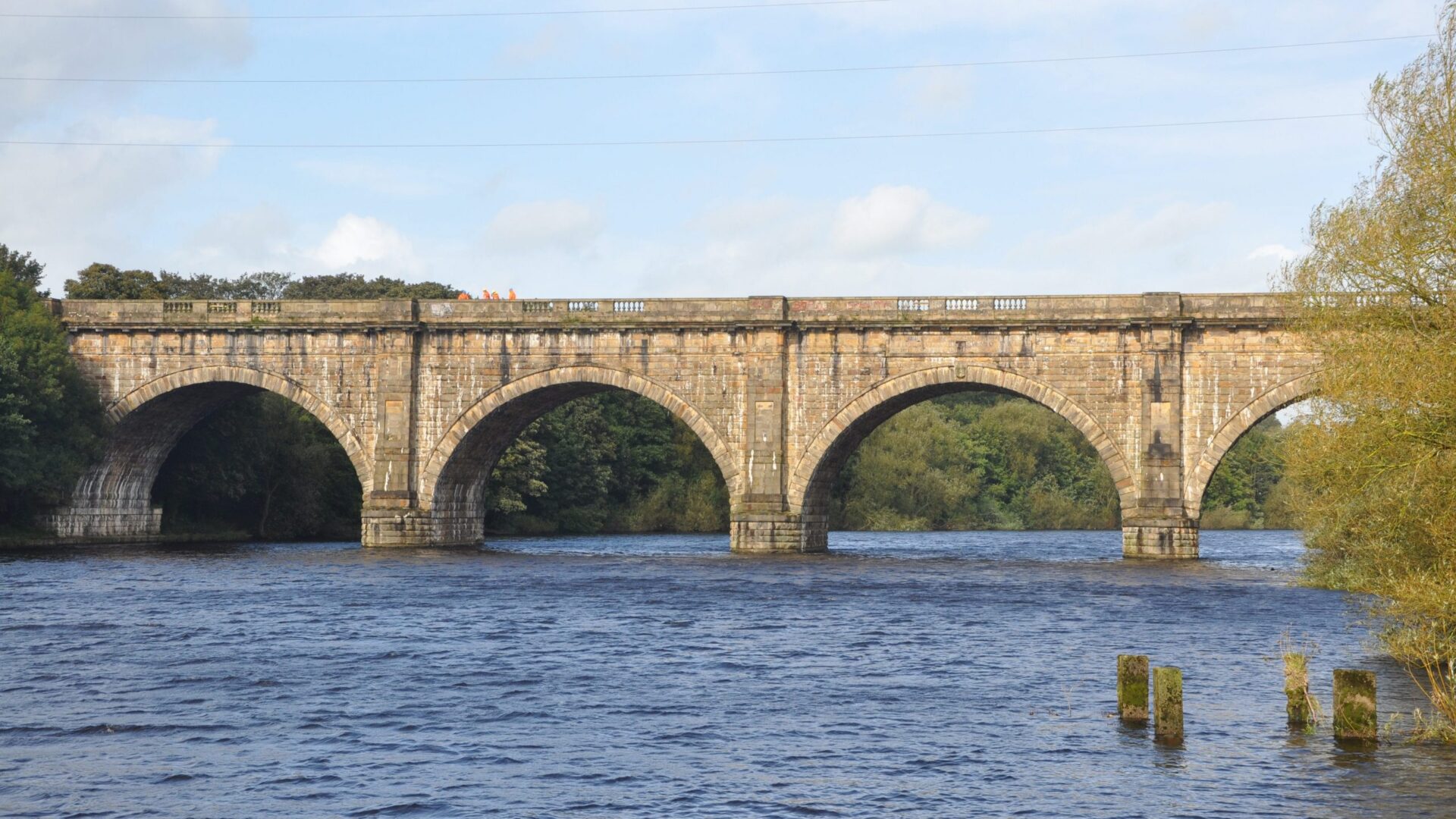
Boats can no longer go on the old canal to where it ends at Town Lane, but the walk route takes us round along tracks and paths to trace the now filled in canal and the Lostock Aqueduct/Embankment that took the canal over the River Lostock.
Two tunnels can then be viewed, which were built as one tunnel back in 1801-03, but then partly opened out in 1837 due to collapses.
We take a lunch stop at the site of the old Duke of York Canal Basin next to one of the last surviving Grade II listed canal bridges on this section, Moss Bridge on Chorley Old Road. Quite a good length of canal bed survives in a dry infilled state and, as our route leaves the old canal, a restored Lime kiln is visited before crossing over the Motorway. The last part of the walk connects back to the Leeds and Liverpool Canal through Lower Copthurst and back to the Top Lock.
Mainly towpaths, paths/tracks. Can be muddy in parts.
Some steps and slopes to negotiate
Car Park opposite the Top Lock pub (PR6 8LT), or nearby street parking on Kenyon Lane if car park full
From the top lock pub, cross the canal bridge, take the towpath steps to head down the flight of 7 locks until you reach the junction with the old Lancaster Canal south section
Cross the junction canal bridge and loop back under it to take the old towpath heading to Town lane along the last in watered length of the old Lancaster Canal built c.1800
Where the canal now ends is the site of an old coal wharf. The footpath joins Town Lane, and you take a right after crossing the road at what was navigation bridge. Take a footpath down a track 100 metres along Town lane, behind stone-built cottages.
Just before entering a farm, take a stile on the left, into a field, followed by another stile 20 metres away alongside the field boundary that takes you along an embankment, with the old canal channel now infilled, below you on the left. Follow the footpath down the valley side and through a Motorway subway (torch recommended)
As you exit the subway, the aqueduct and embankment that took the Lancaster Canal over the river Lostock is now in front of you. Go through the tunnel footpath taking the river and at its exit portal, take the footpath to the left to loop back on yourself, and over the tunnel portal. The footpath climbs steadily through woodland and past cottages.
Before joining the road (Hill Top lane), the track takes you over the canal tunnel, built between 1801-03 as one tunnel and then opened out in its centre after a collapse in 1837. Take a left when you join the road and 200m along take a set of wooden steps down to the canal cutting, partly restored.
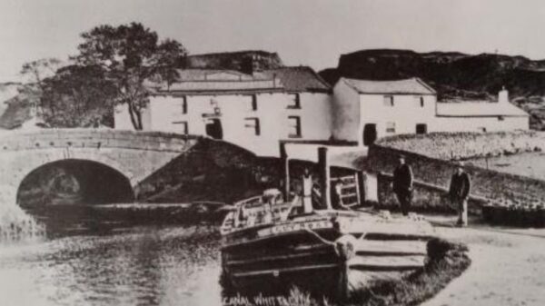
The cutting takes you to Moss Bridge, but look back the other way to the tunnel portal of the west tunnel, clearance work having taken place to make it viewable from the towpath. A 200-year commemoration plaque on the bridge is worth a read before going under the bridge and into the landscaped area that was the Duke of York Basin up until 1968.
The basin has a seating area and recovered mill stones that were once quarried in the area. Take the footpath at the far side of the basin area, northwards at the back of houses that once served as coal yards. On joining Chorley Old Road, cross and turn left, walk down to the Dog Inn pub.
Take the path down the left side of the pub, up steps and across the old canal bed onto a tarmac footpath, turning left and following this path for 150m. Continue for another 20m after crossing an estate road, through a metal gate and take the first footpath right which leads you to a restored stone-built Lime Kiln straight away.
From the Lime Kiln, continue on the footpath through woodland for 250m to join Birchin Lane and turn left to go uphill and left again to cross the Motorway on a high bridge..
Once you have crossed on the motorway bridge, take the first right which is the continuation of Birchin Lane, heading downhill on this country lane to Lower Copthurst and then a short, steep climb back up to the Top Lock and the start point.
Hundreds of miles of waterways – along with their unique heritage and habitats – are currently starved of funding and rely on constant lobbying by us to safeguard their future.
We want boating on canals and rivers to be more sustainable and – even though the current overall contribution to UK carbon emissions is very small – we want to help reduce emissions on the waterways.
Britain’s canals and rivers are a unique, living heritage. But that heritage is at risk – from urban development, lack of protection, loss of skills and knowledge and climate change.
You can help Save Waterways Heritage.
Restoring the UK’s blue infrastructure – our inherited network of navigable canals and rivers – is good for people and places.
Britain's waterways are vital; together we can campaign for them now and for the future.
| Cookie | Duration | Description |
|---|---|---|
| __stripe_mid | 1 year | Stripe sets this cookie to process payments. |
| __stripe_sid | 30 minutes | Stripe sets this cookie to process payments. |
| cookielawinfo-checkbox-advertisement | 1 year | Set by the GDPR Cookie Consent plugin, this cookie records the user consent for the cookies in the "Advertisement" category. |
| cookielawinfo-checkbox-analytics | 1 year | Set by the GDPR Cookie Consent plugin, this cookie records the user consent for the cookies in the "Analytics" category. |
| cookielawinfo-checkbox-functional | 1 year | The GDPR Cookie Consent plugin sets the cookie to record the user consent for the cookies in the category "Functional". |
| cookielawinfo-checkbox-necessary | 1 year | Set by the GDPR Cookie Consent plugin, this cookie records the user consent for the cookies in the "Necessary" category. |
| cookielawinfo-checkbox-others | 1 year | Set by the GDPR Cookie Consent plugin, this cookie stores user consent for cookies in the category "Others". |
| cookielawinfo-checkbox-performance | 1 year | Set by the GDPR Cookie Consent plugin, this cookie stores the user consent for cookies in the category "Performance". |
| CookieLawInfoConsent | 1 year | CookieYes sets this cookie to record the default button state of the corresponding category and the status of CCPA. It works only in coordination with the primary cookie. |
| PHPSESSID | session | This cookie is native to PHP applications. The cookie stores and identifies a user's unique session ID to manage user sessions on the website. The cookie is a session cookie and will be deleted when all the browser windows are closed. |
| Cookie | Duration | Description |
|---|---|---|
| _fbp | 3 months | Facebook sets this cookie to display advertisements when either on Facebook or on a digital platform powered by Facebook advertising after visiting the website. |
| _ga | 1 year 1 month 4 days | Google Analytics sets this cookie to calculate visitor, session and campaign data and track site usage for the site's analytics report. The cookie stores information anonymously and assigns a randomly generated number to recognise unique visitors. |
| _ga_* | 1 year 1 month 4 days | Google Analytics sets this cookie to store and count page views. |
| _gat_gtag_UA_* | 1 minute | Google Analytics sets this cookie to store a unique user ID. |
| _gat_UA-* | 1 minute | Google Analytics sets this cookie for user behaviour tracking.n |
| _gid | 1 day | Google Analytics sets this cookie to store information on how visitors use a website while also creating an analytics report of the website's performance. Some of the collected data includes the number of visitors, their source, and the pages they visit anonymously. |
| CONSENT | 2 years | YouTube sets this cookie via embedded YouTube videos and registers anonymous statistical data. |
| Cookie | Duration | Description |
|---|---|---|
| test_cookie | 15 minutes | doubleclick.net sets this cookie to determine if the user's browser supports cookies. |
| VISITOR_INFO1_LIVE | 5 months 27 days | YouTube sets this cookie to measure bandwidth, determining whether the user gets the new or old player interface. |
| YSC | session | Youtube sets this cookie to track the views of embedded videos on Youtube pages. |
| yt-remote-connected-devices | never | YouTube sets this cookie to store the user's video preferences using embedded YouTube videos. |
| yt-remote-device-id | never | YouTube sets this cookie to store the user's video preferences using embedded YouTube videos. |
| yt.innertube::nextId | never | YouTube sets this cookie to register a unique ID to store data on what videos from YouTube the user has seen. |
| yt.innertube::requests | never | YouTube sets this cookie to register a unique ID to store data on what videos from YouTube the user has seen. |