account arrow-down arrow-left arrow-right closecontact-us emailFacebookheart instagramjoin linkedin phonepinterestplaysearch twitteryoutube

Hurleston Locks & Shropshire Union Canal Walk

This leisurely walk is 6.1km, featuring Hurleston Locks, a reservoir, the Shropshire Union Canal and open countryside.

Walk

Location

Barbridge

Distance

6.1km (3.8 miles)

Ease

Leisurely

activity image

Follow the route to see the Hurleston flight of locks at the top of the Llangollen Canal, and the junction with the Shropshire Union at the bottom of the flight.

All of the footpaths and tracks on this circular walk are in good condition and the level route is easy to follow. There are a few stiles and kissing gates towards the end of the walk. This walk also includes instructions for walkers from moored canal boats.

Spring or summer is the best time to do this walk, when the trees are in leaf.


Walk Details

Surface

The surface is variable. Following heavy rain, some of the tracks will be muddy with numerous puddles.

Parking

Free parking is available in the pub car park for customers, or there you can park on the kerb along the road.

The walk starts at the Barbridge Inn car park in Old Chester Road. Grid ref: SJ 615 567. If you are using a SatNav, enter the post code CW5 6AY or the co-ordinates: 53.10658, 002.57599.

Mooring

Canal boaters should moor at the Barbridge Inn – near Bremilow’s Bridge 100.

Accessibility

The walk includes an alternative route for suitable for pushchairs, wheelchairs and mobility aids, which avoids the stiles. The route can be muddy and a bit bumpy.

Small dogs can be lifted over the occasional stile.

Hurleston Locks & Shropshire Union Canal Walk Map

Find directions to the Activity

Begin The Walk

1. Barbridge Inn

Leave the car park, cross over the road, and turn left. Follow the pavement for about 200 meters keeping round to the right and arrive back at the main road. Keep walking round to the right until immediately opposite – just across the main road, you can see along Mill Pool Lane.

2. Mill Pool Lane

Cross over the A51 Chester Road and walk along Mill Pool Lane for about 300 meters. You will cross a bridge over a very attractive brook. Walk past the footpath on the left and continue along the lane to arrive at some farm buildings.

3. Bullsgreen Farm

Walk through the farm yard, past the distant silo and continue along the concrete drive for half a kilometer. Soon you will pass the watery George’s Rough on your left. As the drive bends sharply right, you will see a farm gate in front of you with a stile alongside it.

4. Through the gate

Having reached the gate into the field, pass through it if it’s open. Otherwise use the stile. Walk into the field and 300 meters straight across it – heading for a gap on the other side. When you reach it pass through and turn left. There’s an old footpath marked on the map before the gap, but the new route is to pass through and use the farm track just beyond.

5. Follow the edge of the field

Continue along this track for about 200 meters, ignoring a track to the left. When you reach the corner of this field you will see the old footpath joining your track from the left.

6. Through the gate

Also, at the corner of the field are tracks each side of the hedge in front of you. Keep left along the track in the photo, and continue forwards with the hedge now on your right for almost half a kilometer to the far corner of the next field.

7. Through the gap

When you reach the corner of the field, you will see the old footpath route over a now impassable footbridge on your left. Pass through this gap instead and keeping to the right, and then continue straight forwards another 200 meters to the corner of the next field.

8. Past the rusty gate

Now you will join the original footpath. There’s an old rusty gate next to the stile, and you may be able to ease it open enough to squeeze through rather than climb the stile. Having passed through the gate, continue across the field to join the old footpath by a large tree, then turn right along to the edge of the field. Walk past the end of a hedge at the corner of the field and join a track along the next field.

9. Over the Brook

The track slopes down to a bridge over a brook. You will see that the ruts have been filled with concrete. Continue along it and you will soon pass the Equine Centre buildings on your right. The track bends left then right to reach the main A51 road. You will reach it after about 200 meters.

10. A51, Chester Road

Cross the road to the bus stop, and continue a short distance along the pavement to a T junction. Turn right and follow the pavement for just about half a kilometer. You will pass the main entrance to the United Utilities Hurleston reservoir. Cross over the Llangollen Canal, and in another 10 meters, you will reach an opening in the hedge on your left. This is the access footpath down to the Canal towpath.

11. Down to the Towpath

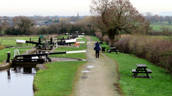
Follow the footpath down to the towpath and turn right. Follow the towpath past a flight of four locks and the high bank of the reservoir. There are picnic tables here where you can rest. At Hurleston the canal descends 34 feet via the four Hurleston Locks to the Shropshire Union Canal, and is one of the busiest canals in the country and the gateway to Wales for boaters.

The Hurleston reservoir was built to keep the Shropshire Union Canal down below supplied with water; it was enlarged in 1959 and now has a capacity of 85 million gallons. As well as supplying water for navigating the Shroppie, the reservoir is also used for drinking water. Around 12 million gallons flow along the Llangollen Canal alongside it each day to keep the reservoir topped up. This gives the canal a much higher current than is normal for most canals. The supply flows all the way down the Llangollen Canal from the River Dee, and the horseshoe falls at Llantysilio were built by the canal engineers just for purpose of feeding water into the canal.

Just past the bottom lock, you will reach a horse bridge over the Shropshire Union Canal.

12. Canal junction & horse bridge

Cross over this horse bridge. When you reach the towpath along the ‘Shroppie’ continue along it with the reservoir bank still on your left. Follow the towpath to the next bridge – No 98.

13. Bridge no. 98 – Shropshire Union Canal

This is bridge 98. Look to your right for a gap in the hedge by a red bin and leave the towpath.

Alternative route: If you have a wheelchair or buggy, continue under the bridge to the next bridge, 99, and re-join this walk at point 18.

14. Leaving the towpath

Pass through the gap in the hedge, and a kissing gate, to arrive at a footpath T junction. Turn left and cross the bridge. Continue along the wide avenue of the quaint and attractive Stoke Manor hamlet for about 200 meters until you reach a road T junction. Turn right here.

15. Follow the Drive

Having turned right, follow this road for 100 meters to a footpath finger signpost at the next junction. Then turn right again.

16. The old dovecote

You should see an old small dovecote on a post on your left. Continue for about 100m, passing through a wooden field gate, across a small courtyard and through an old steel gate just beyond. Walk across the grass to a stile you can see in the distance by some large trees.

17. Over the stile

Climb over the stile and follow the narrow footpath for a quarter of a mile. First along the line of the trees, and at the end of the field look 45° to the right and in the distance you will see the top of canal bridge 99. Walk directly across the field towards it.

18. The Shroppie, bridge 99

This is bridge 99; climb over the stile and cross over the bridge to a footpath’s junction. Ignore the kissing gate in front of you and instead turn right and pass through the one leading down to the towpath, turn right and walk under the bridge. This is where anyone with a wheelchair or buggy would rejoin the route. Continue along the towpath another quarter of a mile to the next bridge 100.

Boaters will now have reached the end of the walk and can return to their mooring.

19. The Shroppie, bridge 100

Here is bridge 100. Fork right and climb the steps up to the lane and turn left to cross the bridge. Then immediately turn right, then right again at the ‘T’ junction with Old Chester Road. Look out for the Barbridge Inn. You have now completed the walk.

Downloads available soon

Explore Nearby

Guided Walk Events

Related activities

Waterway underfunding

Hundreds of miles of waterways – along with their unique heritage and habitats – are currently starved of funding and rely on constant lobbying by us to safeguard their future.

Sustainable Boating

We want boating on canals and rivers to be more sustainable and – even though the current overall contribution to UK carbon emissions is very small – we want to help reduce emissions on the waterways.

Waterways Heritage at Risk

Britain’s canals and rivers are a unique, living heritage. But that heritage is at risk – from urban development, lack of protection, loss of skills and knowledge and climate change.

You can help Save Waterways Heritage.

Waterway restoration

Restoring the UK’s blue infrastructure – our inherited network of navigable canals and rivers – is good for people and places.