account arrow-down arrow-left arrow-right closecontact-us emailFacebookheart instagramjoin linkedin phonepinterestplaysearch twitteryoutube

Caldon Canal

The Caldon Canal runs from Etruria to Froghall, through the heart of the once-industrialised Potteries before heading up into the Staffordshire Moorlands.

Caldon Canal Map

Burslem Branch Canal Trent & Mersey Canal Conservation Area

Facts & Stats

20miles

(27 km)

The length of the Caldon Canal which is navigable including the Leek Arm.

17 locks

+ 3 Lift bridges

and 2 tunnels.

1974

Year restored

However the final half-mile of the Leek Branch remained buried beneath an industrial estate.

From Etruria to Froghall

The Caldon Canal runs from Etruria to Froghall, through the heart of the once-industrialised Potteries before heading up into the Staffordshire Moorlands.

It joins the Trent and Mersey Canal at Etruria Junction and terminates at the junction with the Uttoxeter Canal at Froghall, where the first lock of the Uttoxeter Canal has recently been restored and leads to a basin with visitor moorings.

There is one branch (the Leek Branch), which runs from Hazelhurst Junction to the outskirts of Leek, just short of its original terminus. The branch is 3 miles (4.8 km) long, has no locks and one tunnel. 

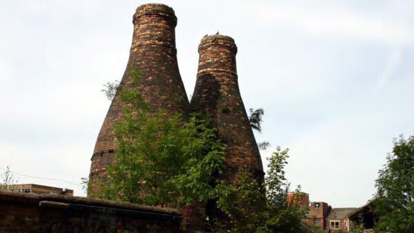
This part of the Trent and Mersey system was built to carry limestone from the quarries around Froghall and the remains of many limestone kilns can still be seen in the area. When the Caldon Canal was restored to navigation in 1974, the final half-mile of the Leek Branch remained buried beneath an industrial estate. 

During 2003, Caldon and Uttoxeter Canals Trust (formerly Caldon Canal Society), with support from IWA, put in place funding for a feasibility study to examine ways to improve the current terminus and to extend the Canal back toward the market town of Leek. At the terminus of the main line of the Caldon Canal, BW undertook substantial repairs to the canal channel in 2003 to overcome problems of subsidence and, with a new concrete channel lining, has been able to lower the water level in the final pound without any reduction in minimum depth. This has enabled more boats to pass through the low profile of Froghall Tunnel.

Waterway notes

Maximum boat sizes

  • Length: 74′ 9″ (22.79 metres) – lock 16 (Oakmeadowford Lock)
  • Beam: 7′ 4″ (2.25 metres) – lock 17 (Flint Mill Lock)
  • Height: 6′ 2″ (1.88 metres) – bridge 10 – and 5′ 0″ (1.52 metres) through Froghall Tunnel
  • Draught: 4′ 3″ ( 1.3 metres) – lock 16

Navigation authority

Canal & River Trust

Useful info

  • Locks 1 and 2 at Etruria are in a staircase.
  • A handcuff key is required for anti-vandal locks at Lock 3 (Planet)
  • A Sanitary Station key is required to operate the lift bridges 11 (Ivy House) and 21 (Norton Green)
  • A windlass is required to operate lift bridge 23 (Long Butts)

Waterway news

Waterway underfunding

Hundreds of miles of waterways – along with their unique heritage and habitats – are currently starved of funding and rely on constant lobbying by us to safeguard their future.

Sustainable Boating

We want boating on canals and rivers to be more sustainable and – even though the current overall contribution to UK carbon emissions is very small – we want to help reduce emissions on the waterways.

Waterways Heritage at Risk

Britain’s canals and rivers are a unique, living heritage. But that heritage is at risk – from urban development, lack of protection, loss of skills and knowledge and climate change.

You can help Save Waterways Heritage.

Waterway restoration

Restoring the UK’s blue infrastructure – our inherited network of navigable canals and rivers – is good for people and places.

Local activities