account arrow-down arrow-left arrow-right closecontact-us emailFacebookheart instagramjoin linkedin phonepinterestplaysearch twitteryoutube

River Severn

The River Severn is managed as a navigation from Gladder Brook, upstream of Stourport, down to Gloucester where it connects to the Gloucester and Sharpness Ship Canal. 

Map showing the River Severn and surrounding waterways

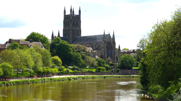
Worcester Cathdral overlooking the River Severn

Facts & Stats

42.6 miles

(67.6km)

The length of the River Severn managed by Canal & River Trust.

5 locks

1503

First Act

This has been an active transport route since Roman times. Its first Act of Parliament was passed in 1503 – and many more followed in attempts to tame the longest river in Britain.

From Gladder Brook to Gloucester

It also connects to the Staffordshire and Worcestershire Canal at Stourport, the Droitwich Barge Canal at Hawford, the Warwickshire Avon at Tewkesbury and to the Worcestershire and Birmingham Canal at Worcester. 

There is a right of navigation upstream of Gladder Brook as far as Pool Quay, Welshpool, and the former Severn Navigation Restoration Trust worked for many years to encourage improvement for navigation of this part of the river. The Trust’s final chairman has an article covering the Trust’s work.

The river below Gloucester is navigable, but tidal. The Herefordshire & Gloucestershire Canal (under restoration) connects to the (now closed) Maismore Channel of the river at Over on the outskirts of Gloucester. The former Coombe Hill Canal (closed and now a nature reserve) connected to the river near Apperley.  

This has been an active transport route since Roman times. Its first Act was passed in 1503 and many more followed in attempts to tame the longest river in Britain. Nineteenth century improvements and adjoining new canals increased the use of the waterway. The River Severn was one of the most important industrial arteries of this Country once navigated by trows from Gloucester Docks and the Severn Estuary to Pool Quay near Welshpool in good conditions. As canals such as the Worcester & Birmingham were completed, they provided links for exporting products from the industrial Midlands via the Severn and it prospered in the late eighteenth century with coal from Madeley and Broseley to the Droitwich saltworks and to other industries. Locks were only introduced in 1834 with five from Stourport to Tewkesbury.

Waterway notes

Maximum boat sizes

  • Length: 93′ 6″ (28.49 metres) – Bevere Lock
  • Beam: 20′ 0″ (6.1 metres) – Worcester Bridge
  • Height: 20′ 3″ (6.2 metres) – Worcester Bridge (at summer level – river levels can fluctuate)
  • Draught: 6′ 1″ (1.85 metres) – cill of Lincomb Lock

Navigation authority

Branch

Useful Info

The locks on the Severn are operated by lockkeepers (restricted hours).

Waterway underfunding

Hundreds of miles of waterways – along with their unique heritage and habitats – are currently starved of funding and rely on constant lobbying by us to safeguard their future.

Sustainable Boating

We want boating on canals and rivers to be more sustainable and – even though the current overall contribution to UK carbon emissions is very small – we want to help reduce emissions on the waterways.

Waterways Heritage at Risk

Britain’s canals and rivers are a unique, living heritage. But that heritage is at risk – from urban development, lack of protection, loss of skills and knowledge and climate change.

You can help Save Waterways Heritage.

Waterway restoration

Restoring the UK’s blue infrastructure – our inherited network of navigable canals and rivers – is good for people and places.