1. Ruabon Brook Railway
Leave the main car park by the exit at the south end. The path here is on the route of the Ruabon Brook Railway. At the entrance to the Trevor Basin site, take the left hand path.
Pontcysyllte Aqueduct is the most spectacular sight on the canal network and is the focus of the World Heritage Site. Trevor Basin has lots of historical interest.
Pontcysyllte Aqueduct is eleven miles of canal from Chirk Bank to Horseshoe Falls was named a World Heritage Site in July 2009. The Pontcysyllte Aqueduct and Canal are early and outstanding examples of the innovations brought about by the Industrial Revolution in Britain, where they made decisive development in transport capacities possible.
Tarmac surface, but not really wide enough on the aqueduct for a wheelchair.
At Trevor — follow the signs. (Only vehicles for disabled persons may park in the car park immediately adjacent to Trevor Basin.)
At Trevor Basin.
Leave the main car park by the exit at the south end. The path here is on the route of the Ruabon Brook Railway. At the entrance to the Trevor Basin site, take the left hand path.
Trevor Basin was partly built on an artificial terrace retained by a stone wall at the south-east. The house has been used as accommodation for canal-related workers and later as a public house. The twin dry docks (one roofed) were built within a few years of the opening of the canal. Behind the former store (now the visitor centre) are double wrought-iron basins on a masonry hearth to boil pitch.
Once you reach the aqueduct, there is the option to turn around and walk the same route back. Or continue for another half mile as far as Froncysyllte lime kilns.
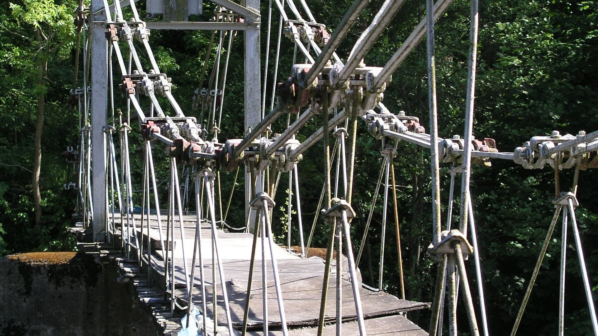
Pontcysyllte Aqueduct, completed in November 1805, is a 19 span cast-iron aqueduct on tapering masonry piers, is 1,007ft long with a maximum height of 126ft above the Dee. The trough is formed from plates one inch thick, the joints made watertight with flannel impregnated with white lead. Supporting each 44ft span are four ribs, cast in three sections, bolted together with connecting plates, the outermost ribs being infilled to give the impression of a solid span.
The name Pontcysyllte, literally ‘the bridge which joins’.
If you are extending this walk and have reached the Froncysyllte lime kilns, the walk can be extended for a further four miles to create a round trip. Continue on the towpath to the main road (B5605) bridge, then walk down the main road, across Rive Dee and up the other side. Turn left under the railway bridge, then enter Ty Mawr Country Park. A footpath takes you down to the river then along the bank back to the aqueduct.
Hundreds of miles of waterways – along with their unique heritage and habitats – are currently starved of funding and rely on constant lobbying by us to safeguard their future.
We want boating on canals and rivers to be more sustainable and – even though the current overall contribution to UK carbon emissions is very small – we want to help reduce emissions on the waterways.
Britain’s canals and rivers are a unique, living heritage. But that heritage is at risk – from urban development, lack of protection, loss of skills and knowledge and climate change.
You can help Save Waterways Heritage.
Restoring the UK’s blue infrastructure – our inherited network of navigable canals and rivers – is good for people and places.
Britain's waterways are vital; together we can campaign for them now and for the future.
| Cookie | Duration | Description |
|---|---|---|
| __stripe_mid | 1 year | Stripe sets this cookie to process payments. |
| __stripe_sid | 30 minutes | Stripe sets this cookie to process payments. |
| cookielawinfo-checkbox-advertisement | 1 year | Set by the GDPR Cookie Consent plugin, this cookie records the user consent for the cookies in the "Advertisement" category. |
| cookielawinfo-checkbox-analytics | 1 year | Set by the GDPR Cookie Consent plugin, this cookie records the user consent for the cookies in the "Analytics" category. |
| cookielawinfo-checkbox-functional | 1 year | The GDPR Cookie Consent plugin sets the cookie to record the user consent for the cookies in the category "Functional". |
| cookielawinfo-checkbox-necessary | 1 year | Set by the GDPR Cookie Consent plugin, this cookie records the user consent for the cookies in the "Necessary" category. |
| cookielawinfo-checkbox-others | 1 year | Set by the GDPR Cookie Consent plugin, this cookie stores user consent for cookies in the category "Others". |
| cookielawinfo-checkbox-performance | 1 year | Set by the GDPR Cookie Consent plugin, this cookie stores the user consent for cookies in the category "Performance". |
| CookieLawInfoConsent | 1 year | CookieYes sets this cookie to record the default button state of the corresponding category and the status of CCPA. It works only in coordination with the primary cookie. |
| PHPSESSID | session | This cookie is native to PHP applications. The cookie stores and identifies a user's unique session ID to manage user sessions on the website. The cookie is a session cookie and will be deleted when all the browser windows are closed. |
| Cookie | Duration | Description |
|---|---|---|
| _fbp | 3 months | Facebook sets this cookie to display advertisements when either on Facebook or on a digital platform powered by Facebook advertising after visiting the website. |
| _ga | 1 year 1 month 4 days | Google Analytics sets this cookie to calculate visitor, session and campaign data and track site usage for the site's analytics report. The cookie stores information anonymously and assigns a randomly generated number to recognise unique visitors. |
| _ga_* | 1 year 1 month 4 days | Google Analytics sets this cookie to store and count page views. |
| _gat_gtag_UA_* | 1 minute | Google Analytics sets this cookie to store a unique user ID. |
| _gat_UA-* | 1 minute | Google Analytics sets this cookie for user behaviour tracking.n |
| _gid | 1 day | Google Analytics sets this cookie to store information on how visitors use a website while also creating an analytics report of the website's performance. Some of the collected data includes the number of visitors, their source, and the pages they visit anonymously. |
| CONSENT | 2 years | YouTube sets this cookie via embedded YouTube videos and registers anonymous statistical data. |
| Cookie | Duration | Description |
|---|---|---|
| test_cookie | 15 minutes | doubleclick.net sets this cookie to determine if the user's browser supports cookies. |
| VISITOR_INFO1_LIVE | 5 months 27 days | YouTube sets this cookie to measure bandwidth, determining whether the user gets the new or old player interface. |
| YSC | session | Youtube sets this cookie to track the views of embedded videos on Youtube pages. |
| yt-remote-connected-devices | never | YouTube sets this cookie to store the user's video preferences using embedded YouTube videos. |
| yt-remote-device-id | never | YouTube sets this cookie to store the user's video preferences using embedded YouTube videos. |
| yt.innertube::nextId | never | YouTube sets this cookie to register a unique ID to store data on what videos from YouTube the user has seen. |
| yt.innertube::requests | never | YouTube sets this cookie to register a unique ID to store data on what videos from YouTube the user has seen. |