account arrow-down arrow-left arrow-right closecontact-us emailFacebookheart instagramjoin linkedin phonepinterestplaysearch twitteryoutube

Birmingham Canal Old Main Line

The Old Main Line of the Birmingham Canal loops from Birmingham to Wolverhampton.  6.6 miles of its 13.4 mile length are currently navigable.  

Birmingham Canal Old Main Line Map

Facts & Stats

6.6 miles

(10.6 km)

The length of the Birmingham Canal Old Main Line which is navigable

3 locks

Oldest on the BCN

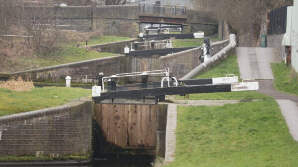
The 3 remaining Spon Lane locks on the Old Main line are the originals from 1769 making them the oldest on the BCN

1768

Authorised

Surveyed and engineered by James Brindley, the Birmingham Canal was authorised in 1768 to connect Birmingham to the Staffordshire & Worcestershire Canal near Wolverhampton and with a branch to Wednesbury. The Wednesbury line was completed first, in 1769.


From Smethwick Junction to Tipton factory Junction

Construction

Surveyed and engineered by James Brindley, the Birmingham Canal was authorised in 1768 to connect Birmingham to the Staffordshire & Worcestershire Canal near Wolverhampton and with a branch to Wednesbury, the nearest coal mines to the city.  The Wednesbury line was completed first, in 1769, some 10 miles from Birmingham to collieries at Hill Top in West Bromwich.  It crossed higher ground by rising through 6 locks at Smethwick to a 1 mile summit level then descending through 6 locks at Spon Lane.  That both ends were at the same ‘Birmingham level’ of 453 feet o.d. may indicate Brindley planning ahead to cut through the summit, but the limited finance and engineering techniques of his day meant that would have to wait 60 years for completion.

Brindley’s originally surveyed route had apparently continued the Birmingham level via Tipton and Bilston right through to Wolverhampton, but this was raised 20 feet to the present ‘Wolverhampton level’ at 473 ft to take the route closer to Oldbury and to Dudley with its limestone and ironstone mines.  From Spon Lane Junction, half way down the then 6 lock flight, the main line of the canal was continued along the contours, taking a somewhat winding course to Wolverhampton where it dropped through 20 locks to join the Staffordshire & Worcestershire Canal at Aldersley Junction by 1772, some 22½ miles and 29 locks from Birmingham.  Water was supplied from reservoirs at Smethwick, by 1774 from Titford Pool, and soon from various mine pumping engines discharging into the canal.

Connections

There were two original termini in Birmingham by 1772; the canal dividing at Old Turn Junction to access wharfs at Newhall Street, and via Broad Street Tunnel to Gas Street Basin and Paradise Wharf.  The Newhall Branch beyond Cambrian Wharf is now built over, as is a later (1812) branch from this which included a tunnel and a lock up to Gibsons Wharf.  The Old Wharf basins at Paradise Street which included the canal company offices have also been lost to development.

Although initially joined externally only to the Staffordshire & Worcestershire Canal, it was not long before the Birmingham Canal was connected in several directions to the growing canal network.  In 1789 the Birmingham & Fazeley Canal joined the Birmingham Canal at the top of Farmers Bridge Locks, although by then the two companies had merged (Originally as the rather long-winded ‘Birmingham and Birmingham and Fazeley Canal Navigations’ but changed in 1794 to the Birmingham Canal Navigations).  By 1792 the Dudley Canal had been extended through Dudley Tunnel to join the earlier branch into the limestone mines from Tipton Junction.  The Wyrley & Essington Canal opened in 1794 from Horseley Fields Junction to collieries at Great Wyrley & Essington, and was extended by 1797 via Walsall to Lichfield and the Coventry Canal.  The Worcester & Birmingham Canal was connected at Worcester Bar in 1815.

Internal additions to the BCN system which connected with the original Birmingham Canal include the Walsall Canal, opened initially in 1785 from the Wednesbury Branch (or Wednesbury Old Canal) at Ryders Green Junction down 8 Locks to Ocker Hill, and later extended in phases to Walsall.  The Ridgacre Branch off the Wednesbury Old Canal dates from 1827.  The Titford Canal, which connects via the 6 Titford Locks (or ‘The Crow’) was opened in 1837, the Bradley Locks Branch with 9 locks connecting the Wednesbury Oak Loop  to the Walsall Canal in 1849, and the Netherton Tunnel Branch in 1858.

There were numerous other internal connections with loops, branches, arms and basins, of which only the more significant can be mentioned here.

Improvements to the Canal

An early improvement was to add an extra lock to the Wolverhampton flight; for some reason the bottom lock had been built with a bigger fall than the others which obviously wasted water so in 1784 its drop was reduced and an extra lock (now Lock 20) added above it.

More major improvements were needed to cope with the growing water shortages on the short summit level and steam pumping engines supplied by Boulton & Watt had been erected at both ends by 1779 to recirculate the lockage water; the first canal back-pumping system.  But congestion at the locks led to engineer John Smeaton being engaged to lower the summit by cutting through the hill at the Wolverhampton level, eliminating 3 locks at each end.  This was completed by 1790 and the 3 remaining Smethwick locks were also duplicated with a parallel flight to reduce traffic delays.  (Only the later flight remains in use today although the line of the original locks can still be seen, but the 3 remaining Spon Lane locks are the originals from 1769 and thus the oldest on the BCN.)

However, traffic continued to increase and the locks at Smethwick remained a bottleneck so in 1824 engineer Thomas Telford was consulted and recommended extensive improvements to the main line.  Starting from Birmingham, by 1827 a new wider and deeper channel with twin towpaths was cut straight across the original winding route, leaving the Ouzells Street Loop, Icknield Port Loop and Soho Loop to serve the extensive works that lined their banks.  These still survive, although the following Cape Loop is largely closed and the Soho Foundry loop has all disappeared.

From Smethwick Junction an impressive cutting was excavated up to 70 feet deep to continue the new canal at the Birmingham level through to Bromford Junction at the foot of the Spon Lane locks.   By Smethwick Top Lock Telford built an attractive single-span cast iron aqueduct to carry the Engine Arm canal, and several road bridges which cross the Galton Valley cutting including the magnificent cast iron Galton Bridge.  Near Spon Lane Junction this ‘New Main Line’ canal passes under the more conventional two-arched brick-faced Steward Aqueduct which carries the original route which became known as the ‘Old Main Line’.  Many of the distinctive Horseley Iron Works bridges carrying the towpaths over new junctions were also erected at this time, with some later additions made at the Toll End Works.

A unique feature of the New Main Line is the toll islands built midstream at various key points.  These originally carried a small brick tollhouse and many have central lay-by channels for gauging boats.  None of the original tollhouses survive but a replica has been built at Smethwick Top Lock.  As part of his improvements, Telford also built the Rotten Park or Edgbaston reservoir in 1826 which fed both into the Soho Loop and by a long feeder into the end of the Engine Arm.  This superseded the original Smethwick Great Reservoir which has since been built over.

The Galton Valley section was opened by 1829 and the huge amount of material excavated was already being used to build the extensive embankments of the ‘Island Line’ which continues the New Main Line from the Wednesbury Old Canal at Pudding Green Junction in a dead straight line for over 2 miles to Tipton.  Here the 3 Factory Locks raise it to join the Old Main Line again at Tipton Factory Junction.  From Tipton a new canal through Coseley Tunnel was built, again with twin towpaths, cutting out the long and circuitous Wednesbury Oak Loop, part of which remains open today as the Bradley Arm.  All these improvements were completed by 1838 and shortened the through route by no less than 7 miles, from 22½ miles to 15½ miles.

The Old Main Line had itself been shortened in 1821 by straightening which left the Oldbury and Brades Loops, both now closed.  The Gower Branch with the 3 Brades Locks, 2 of which form the only staircase on the BCN, was opened in 1836 to give another connection between the Old and New Main lines.  A further connection, now lost, had been created where the Island Line cut across the Tipton Green Branch, dating from 1809.  This formerly continued via the Toll End Communication Canal through to the Walsall Canal.

Later improvements included a new Pumping Station opened in 1892 near Brasshouse Lane in Smethwick to raise water between the two canal levels.  In 1974 a new road was built when Galton Bridge was pedestrianised, crossing the Galton Valley on earth embankments and including two new concrete ‘tunnels’, Galton Tunnel on the New Main Line and Summit Tunnel on the Old Main Line.

Traffic, Decline and Revival

Commercial traffic on the Birmingham canal was heavy and varied for nearly 200 years, including coal, coke, limestone, iron, clay, bricks, tiles, timber, tar, gasoil, nightsoil, manure, rubbish, horse provender, foodstuffs, beer and all manner of manufactured goods.  Although built for the standard narrow boat, the lock-free Wolverhampton level of the Birmingham and Wyrley & Essington canals was large enough for a special size of narrow boat known as ‘Ampton’ boats or Wharf boats up to 86ft length by 7ft 9in beam to maximise capacity.  The BCN remained busy well into the railway age when other canals succumbed to the competition, with extensive rail interchange wharfs for local collection and deliveries.

But by the 1950s traffic was much reduced and several sections of the BCN were closed including the Wednesbury Oak Loop from Bradley to Bloomfield Junction (1955), the Oldbury Loop (1960), much of the Wednesbury Old Canal (1960), Bradley Locks (1961), Tipton Green & Toll End Communication (1966) and many of the shorter branches.  The Ridgacre Branch was cut off by a new road in 1995.  However, about 100 miles of the original 160 miles of the BCN system survive, including all the New Main Line and much of the original route on the Old Main Line.

The traffic is now all for pleasure and inevitably the built-up and industrial nature of the surroundings mean the BCN is less used than many other waterways.  But the Birmingham Canal itself is a key link in the centre of the national system and the New Main Line is well used as a through route.  In recent years much of the old industry has been swept away and, whilst we may regret the loss of historic buildings, new development and the greening of the canal corridor as pollution has declined are opening up attractive new surroundings which promise a bright future for the Birmingham Canal.

Waterway notes

Maximum boat sizes

  • Length: 70′ 11″ (21.62 metres)
  • Beam: 7′ 4″ (2.24 metres)
  • Height: 7′ 5″ (2.26 metres)
  • Draught: 4′ 4″ (1.32 metres)

Navigation authority

Waterway underfunding

Hundreds of miles of waterways – along with their unique heritage and habitats – are currently starved of funding and rely on constant lobbying by us to safeguard their future.

Sustainable Boating

We want boating on canals and rivers to be more sustainable and – even though the current overall contribution to UK carbon emissions is very small – we want to help reduce emissions on the waterways.

Waterways Heritage at Risk

Britain’s canals and rivers are a unique, living heritage. But that heritage is at risk – from urban development, lack of protection, loss of skills and knowledge and climate change.

You can help Save Waterways Heritage.

Waterway restoration

Restoring the UK’s blue infrastructure – our inherited network of navigable canals and rivers – is good for people and places.

Local activities