Any grand scheme to connect across the southwest peninsular would, sensibly, utilise as many natural water courses as possible along the way, just so long as they were flowing in more or less the right direction.
A quick glance at a map shows that, in practical terms, these amount to the Rivers Parrett, Tone, Exe, Culm, Clyst, Otter and Axe. By 1638, the rivers Parrett and Tone had already been made navigable to Ham Mills – a point on the river Tone just three mile short of Taunton.
Until 1717, when the Tone Conservators set about completing the final link into the town, the upkeep of the navigation remained in the hands of one John Mallet and his heirs. By 1724 there was a continuous towing path throughout the length of the navigation and the central piece of the Bristol to English Channels Concern jigsaw puzzle was now in place.
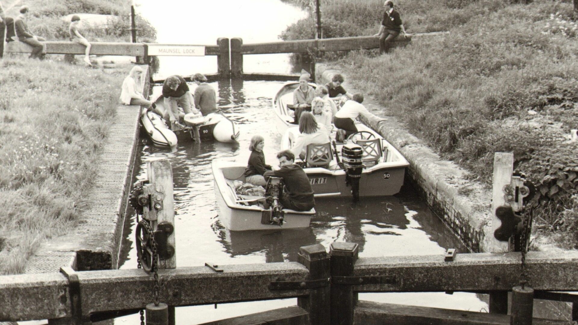
[The photo above shows an IWA Campaign Cruise at Maunsel Lock on the Bridgwater and Taunton Canal on 16th May 1982 – by J Reeves]
Forty four years later a group of ‘Taunton Men’ proposed the Exeter & Uphill Canal, running via Taunton, Bridgwater and Axbridge to Uphill on the Bristol Channel, just south of Weston-Super-Mare. Axbridge would connect with the various mining interests in the area surrounding the Mendip Hills. This was a route that was surveyed by James Brindley and Robert Whitworth and, as such, came laced with considerable kudos.
Whilst engaged in this survey, Whitworth conducted a further exercise, and a year later presented a route from Langport – on the Parrett, east of its junction with the Tone – almost due south to Seaton on the Axe estuary with the English Channel. The distance between translating theory (the survey) into practice was, like the route in question, never going to be a short one and matters languished for a full quarter of a century until a more extensive line between Axminster (again on the Axe Estuary) and Uphill – via collieries at Nailsea, south of Bristol – was surveyed by one Joseph Easton.
Two years earlier, Whitworth’s surveyor’s staff had again been active in the West Country when, on 1st October 1792, the inaugural meeting of the Grand Western Canal Company was held to present a scheme for a navigation linking Topsham with Taunton. Yet more jigsaw pieces, to complete the picture for the southern section of the Bristol to English Channel Concern, joined those already littering the proposer’s table.
[The photo, left, shows Albert Street Cutting, Bridgwater, Bridgwater & Taunton Canal – by Derek Pratt (IWA Collection)]
In December of the same year, we also witness an attempt to fully complete the northern section of the puzzle, with a new proposal – surveyed by Messrs Longbotham and White – known as the Bristol & Western Canal, running from Morgan’s Pill, near the mouth of the Bristol Avon to Taunton. This would, of course, be directly complimentary to the ideas of the Grand Western Canal promoters, launched only two months earlier, thereby completing the link in just two hops.
As a further component in this flurry of renewed interest, Whitworth, in 1793, received to second call to attend his various masters in the West Country, whereupon he was asked to re-survey his earlier Langport to Seaton line to be revived in the form of the first Chard Canal. Pausing once again to draw breath, after so large a bout of renewed activity, observers were rewarded in 1810 when work actually commenced at Holcombe Regis, on the Grand Western Canal – which had been authorised in1796 – under the supervision of John Rennie. A year later Whitworth’s first Chard Canal plan was revived – going under the grandiose title of the English & Bristol Channels Canal, with an additional input from Messrs W. Bond and J. Dean.
1811 also saw the Bristol & Taunton Canal (previously known as the Bristol & Western Canal) obtain its Act, now under the guiding hand of John Rennie who was, of course, the current surveyor for the Grand Western. Guided, perhaps, by Rennie’s grasp of the larger, economic picture, plans for this waterway’s mainline south to Topsham had been quietly dropped and, instead, the branch to Tiverton took on this mantle. Three years later, an 11-mile stretch of the Grand Western Canal, linking Tiverton with the remote, limestone-rich, Lowdwells to the north, finally opened to traffic on 25th August 1814. Apart from the much earlier activity on the Parrett and Tone, this canal represented the first actual construction in getting on for 200 years of grandiose deliberation.
[The photo, right, shows the scraper dredger ‘Bertha’ from the Bridgwater & Taunton Canal at the former Exeter Maritime Museum – by Roy Westlake. ‘Bertha’ worked at Bridgwater Docks from the 1840s to the 1960s, then ended up at the Exeter Maritime museum until that closed, then went to Eyemouth, which in turn closed. Bertha is now back in Bristol and there are proposals to restore it, but significant funding will be required.]
However, despite a lack of further activity on the ground, the Bristol & Taunton Canal Company was (over a four year period) quietly buying up all the shares in the River Tone – a navigation that would be in direct competition with the southern-most section of their proposed waterway. Following his recent success with the completion of the relatively low-key Bude Canal, James Green was invited to report on an English & Bristol Channels Canal in 1821 and, predictably, his recommendation was for a tub boat navigation. Three years later, this proposal had bloated out of all recognition into the form of a ship canal – taking 200 ton vessels – following consultation with no less a man than Thomas Telford.
Meanwhile, firmly grounded in the realms of reality, work had commenced on the Bridgwater to Taunton section of the Bristol & Taunton Canal, under the supervision of James Hollinsworth. This was opened to a connection with the River Parrett, just east of Bridgwater, on 3rd January 1827, having taken three years to construct. Whilst this represented another piece of the jigsaw, in completing the picture of the central section of a Channel-to-Channel link, in reality it merely replaced a long-standing, albeit circuitous, navigation made up from two somewhat unreliable rivers.
Undaunted by Telford‘s high-jacking of his tub boat proposal for the Chard Canal, James Green bounced back in 1830 with a survey for a 13½-mile waterway connecting the northern extremity of the Grand Western Canal, with the Bridgwater to Taunton section of navigation, at its southern terminus on the River Tone. As one of the first examples of practical, joined up thinking in West Country canal construction, this must have come as something of a relief to those already financially burdened by investment in isolated stretches of unfinished waterway. And, yes – true to form – this was to be a tub boat canal, with one inclined plane, seven boat lifts and, as something of an after-thought, a single pound lock.
[The photo, left, taken in 1988, shows at aqueduct on the Grand Western Canal over the River Tone – by Gerry Hollington]
A year later, on 13th June, work commenced on this project – one that was to have an unhappy outcome for Green, who failed to complete the inclined plane at Wellisford, following a spate of problems with the construction of the lifts as well. He was replaced by Captain John Twisden (RN retd.) and the canal finally opened on 28th June 1838. In the meantime, an Act had been obtained to take the Bridgwater & Taunton Canal the additional mile into new docks in Bridgwater, with connecting locks into the River Parrott, supervised by Thomas Maddicks. This was completed four years later in 1841. There was now no reference to a northern River Avon terminus and vessels were left to make their way to Bristol via the Parrett and Bristol Channel.
In 1834, whilst James Green was battling with the engineering challenges of his design for the Grand Western extension to Taunton, the 21-year old Sydney Hall was getting to grips with constructing the Chard Canal. Ironically, it would appear that Telford’s ship canal had sunk without trace and the scheme had reverted, almost in its entirety, to Green’s tub boat/inclined plane conception – but without the boat lifts.
Eight years later the Chard Canal was completed throughout and, crowded along its 13½-mile length, were three tunnels and three inclined planes. An extract from a piece in Woolmer’s Exeter & Plymouth Gazette records the final opening on 24th May: “This anxiously looked for event took place, quite accidentally, on the Queen’s birthday. We say accidentally because, with the uncertain machinery at the inclined plane, and the celebrated frail rope, it was deemed a moral impossibility to say on what precise day any cargo could be brought to the wharfs”.
[The photo, right, shows Sampford Peverell on the Grand Western Canal – by Roy Westlake]
The writing on the waterway wall was clearly not writ large enough for the rheumy West Country eyesight of the day. By the time the Chard Canal – with all its complexities – was finally completed in 1842, Railway Mania had firmly supplanted its fluvial predecessor and the navigation was, in effect, already pretty much redundant. Despite the deployment of a wide range of eminent waterway engineers (and their protégées) few of the schemes ever saw anywhere near 50% of their intended mileage realised, and can only be relegated to the realm of wild dreams (or nightmares – for those unwise enough to have staked a financial interest).
In all there was an almost 200-year span of planned waterway improvement and construction in the South West, in pursuit of the English and Bristol Channels Concern. Often these amounted to competing and overlapping schemes, of almost fantasy proportions, when viewed against the backdrop of large tracts of comparatively under-populated, rural countryside, with few established industries. So, the relatively limited goods that were to travel end to end, coast to coast, could never in themselves, be expected to sustain more than a small part of such extravagant, large-scale undertakings.
Had it not been for IWA, all these waterways would likely have disappeared to become just archaeological remains. Campaigns began in the 1970s, and today you can boat along the Bridgwater & Taunton and part of the Grand Western Canal, but the Chard Canal had long demised before IWA arrived on the scene – and so far there have been no serious restoration proposals.
[The photo, left, shows an aqueduct over the former Tiverton Branch railway at East Manley on the Grand Western Canal – by Roy Westlake]