account arrow-down arrow-left arrow-right closecontact-us emailFacebookheart instagramjoin linkedin phonepinterestplaysearch twitteryoutube

River Forth

The River Forth is mostly a tidal wide estuary, stretching 62 miles from Stirling to the Isle of May.  One tributary of the Forth is the River Carron, to which the Forth & Clyde Canal connects.

Things to do nearby

Facts & Stats

62 miles

(100 km)

The length of the navigable River Forth

147 feet

(44.8 metres)

Navigable headroom under the Forth Railway Bridge, at high tide.

11 feet

(3.35 metres)

Draught at Stirling at highest tide

Boating to Stirling

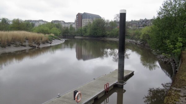
For most of its length the River Forth is a wide tidal estuary, with ample depth.  The Head of Navigation is also the tidal limit, at the remains of an old weir, about 300 metres downstream of where the M9 crosses the river.  In the city, the river is regularly used by canoeists and rowers, and there is a free to use pontoon provided by Stirling Council on the downstream outskirts of the city, which provides easy access to the city centre. Boats can, however, make their way for about a further mile upstream, albeit with no closer access to the city centre owing to loops in the river, and the photo right shows a recent cruise organised by the Royal Yachting Association in Scotland, with boats gathered just upstream of Stirling Rowing Club’s headquarters (the castellated white building shown in the photo), which is just downstream of the rail bridge.   The river shallows a little further upstream, followed by the remains of the old weir.

[Photo by Richard Davies]

Connection to the Forth & Clyde Canal

The River Carron joins the River Firth 18.5 miles (29.8 km) downstream of Stirling.  When originally constructed, the Forth & Clyde Canal joined the Forth through docks at Grangemouth.  When the Canal was restored as part of the Millennium Lottery funded restoration of the lowland canals, restoration through Grangemouth was not practical, so the canal was diverted into the River Carron 1.5 miles (2.4 km) upstream from its confluence with the Forth, but this was not a successful solution.  When the Kelpies were installed at Falkirk in 2013 with further lottery money, the Forth & Clyde Canal was extended along a new 0.6 mile (1 km) cut parallel with the River Carron, known as the Queen Elizabeth II Canal, and a new Sea Lock built, so by-passing a pipe bridge across the Carron.  The photo, left, shows the new sea lock, formally opened in 2014.

Launching Your Boat

Potel Marine, on the River Carron, has ceased trading, so there are now no launching facilities in this area.

[Tidal Lock photo by Neil Edwards]

[Tile Photo by George Gastin, CC BY-SA 3.0 ]

Waterway notes

Navigation authority

Forth Ports Authority was established under a 1967 Act of Parliament as a public trust port responsible for six ports grouped within the Firth of Forth namely – Leith (formerly a trust administered port), Granton (formerly a private company), Grangemouth, Methil and Burntisland (all previously controlled by British Transport Docks Board) and Kirkcaldy (then owned by the Burgh of Kirkcaldy).  Forth Ports transferred to the private sector in 1992 to become Forth Ports Ltd.  Outside of these port areas, there is no navigation authority on the river.

Moorings

Stirling Council provides free pontoon moorings on the river.  The pontoon can be booked – in advance via the Council’s web page, but you may find it easier to call them on 01786 404040.  The town centre and nearest large supermarket is just a ten-minute walk away.

Waterway underfunding

Hundreds of miles of waterways – along with their unique heritage and habitats – are currently starved of funding and rely on constant lobbying by us to safeguard their future.

Sustainable Boating

We want boating on canals and rivers to be more sustainable and – even though the current overall contribution to UK carbon emissions is very small – we want to help reduce emissions on the waterways.

Waterways Heritage at Risk

Britain’s canals and rivers are a unique, living heritage. But that heritage is at risk – from urban development, lack of protection, loss of skills and knowledge and climate change.

You can help Save Waterways Heritage.

Waterway restoration

Restoring the UK’s blue infrastructure – our inherited network of navigable canals and rivers – is good for people and places.

Local activities