account arrow-down arrow-left arrow-right closecontact-us emailFacebookheart instagramjoin linkedin phonepinterestplaysearch twitteryoutube

Staffordshire & Worcestershire Canal

The Staffordshire & Worcestershire Canal links the Trent & Mersey Canal at Great Haywood in Staffordshire with the River Severn at Stourport in Worcestershire.  

Things to do nearby

Facts & Stats

46 miles

(74km)

The length of the Staffordshire & Worcestershire Canal that is navigable.

43 locks

1766

14th May

The Canal was authorised by Parliament.

From the Trent & Mersey Canal to the River Severn

The Staffordshire & Worcestershire Canal connects with the Shropshire Union Canal at Autherley Junction and the Birmingham Canal at nearby Aldersley Junction in Wolverhampton, and with the Stourbridge Canal at Stourton Junction.  

The largely derelict Hatherton Branch joins at Hatherton Junction and is currently only navigable through one lock to a boatyard but its restoration to Cannock and along a new line through to the BCN is being promoted. A former connection with the Stafford Branch or Sow Navigation at Baswich is the subject of restoration proposals as the Stafford Riverway Link.

14th May 1766 is notable in canal history as on that day both the Staffordshire & Worcestershire Canal and the Trent & Mersey Canal were authorised by Parliament. The Staffs & Worcs was the first to be completed in 1772, engineered by James Brindley assisted by Thomas Dadford Senior.  

Joining the River Severn at Stourport to the ‘Grand Trunk’ at Great Haywood, it forms one of the four main arms of Brindley’s vision of canals to link together the rivers Severn, Trent, Mersey and Thames, (later known as Brindley’s Grand Cross) and the only one to be completed in his lifetime.

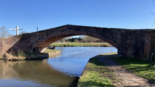
Built to Brindley’s new ‘narrow’ gauge to save money, speed construction and economise on water consumption, the first narrow lock ever built is believed to be the summit lock at Compton in 1766. The whole feel of the Staffs & Worcs Canal is small scale with its vernacular brick bridges, picturesque lock cottages, tiny tunnels and lack of major earthworks.  The summit cutting at ‘Pendeford Rockin’ is so small that even narrow boats cannot pass except in lay-bys; it looks as if they ran out of time or money to make it wider two and a half centuries ago and never got round to finishing it later. Indeed the whole canal seems frozen in time and that is its charm; a perfect survivor from an age of human scale and horse powered transport.  Appropriately, the Staffordshire & Worcestershire Canal is designated as a Conservation Area throughout, which affords it some level of planning protection.

 

Character of the Staffordshire & Worcester Canal

The character of the northern half is more open as it follows the valleys of the rivers Sow and Penk whilst the southern half is more intimate as it winds down the narrow and steeper sided valleys of the Smestow Brook and the River Stour with overhanging sandstone cliffs and several short rock-cut tunnels.  There are some larger engineering features such as the Sow aqueduct and the unique Tixall Wide section, built like a lake to please the estate owner.  Remarkably, its route remains almost entirely rural and it seems now like the perfect leisure waterway but for two centuries it was a busy commercial transport artery.

Autherley Junction & Beyond

As early as 1772 the connection was made at Autherley Junction with the Birmingham Canal to form a major outlet for the minerals and manufactured goods of the Black Country.  From 1779 the Stourbridge Canal connection at Stourbridge Junction brought in even more trade.  When the Birmingham & Liverpool Junction Canal, nowadays known as the Shropshire Union Canal main line, opened in 1835 it diverted some traffic away from the northern part of the Staffs & Worcs but compensation tolls for the short Autherley Junction to Aldersley Junction section helped the Staffs & Worcs Canal Company to remain profitable well into the railway age.  Coal traffic from the Cannock area to Stourport Power Station continued until 1949.  All that boat traffic has added a patina of wear to locks and bridges and to surviving horse boating bridge guards and strapping posts and other small features that enhance the distinctive character of the Staffordshire & Worcestershire Canal.

Waterway notes

Maximum boat sizes

  • Length: 74′ 8″ (22.75 metres) – Awbridge Lock
  • Beam: 7′ 0″ (2.12 metres) – Awbridge Lock
  • Height: 7′ 0″ (2.12 metres) – Whittington Horse Bridge
  • Draught: 3′ 7″ (1.09 metres) – Rodbaston Lock

Navigation authority

Branch

Waterway underfunding

Hundreds of miles of waterways – along with their unique heritage and habitats – are currently starved of funding and rely on constant lobbying by us to safeguard their future.

Sustainable Boating

We want boating on canals and rivers to be more sustainable and – even though the current overall contribution to UK carbon emissions is very small – we want to help reduce emissions on the waterways.

Waterways Heritage at Risk

Britain’s canals and rivers are a unique, living heritage. But that heritage is at risk – from urban development, lack of protection, loss of skills and knowledge and climate change.

You can help Save Waterways Heritage.

Waterway restoration

Restoring the UK’s blue infrastructure – our inherited network of navigable canals and rivers – is good for people and places.